


 Tech Play
Design & Implementation of an Integrated Digital Project Management Platform for Visualization of Road Assets
Infrastructure projects are very complex and hybrid in nature. Managing construction activities of these projects are very crucial. Hence, digital PMC plays a vital role to curb cost & time and providing the single source of truth under a single window solution. Without proper management and visualization, these roads become congestion points, making daily commutes challenging for residents. Recognizing the pressing need, there’s a growing emphasis on digital tools to create 3D models of road infrastructure. This push towards digital visualization necessitates a robust Digital Project Management Platform. Also, the project phases namely Preconstruction, Construction and Operations and Maintenance (O&M) are impacted due to these challenges which leads to impeded efficiency, forfeit project purpose and lesser Returns on Investments (ROI).
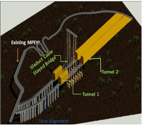
India’s 2 premier business cities, Mumbai and Pune were facing similar challenges in terms of traffic congestion and routing for the commuters on the state highway called as “Mumbai Pune Expressway” (MPEW). MPEW is presently of 6-lane cement concrete pavement with 2.5m wide paved shoulder on both sides having a length of 94 kms. To resolve this issue, Maharashtra State Development Corporation Ltd. (MSRDC) pitched in. MSRDC is a corporation owned by Government of Maharashtra. It is engaged into state-level strategic and integrated infrastructure services, including in the development of roads, bridges and other major infrastructure projects including land, flyover projects, toll collection rights and works under construction which vested with the State Government and were under the control of the Public Works Department but have been subsequently transferred to MSRDC.
MSRDC realized this need and chose Ceinsys as the System Integrator to eradicate this issue. Ceinsys designed and deployed a Digital Project Management Platform, integrating tools like 5DBIM, ERP, and GIS systems, and aiding in the establishment of the Owner’s Support Office (OSO). This arrangement proposed the establishment of an Owner Support Office (OSO) to provide the needed organizational structure, set policies and procedures, and oversee control and tracking mechanisms. This ensured both the successful implementation of the Digital Project Management Platform and the timely completion of the expressway project. Furthermore, a Special Purpose Vehicle (SPV) was created, focusing on improving the expressway’s capacity by implementing the said infrastructural changes.
The project is divided in two packages:
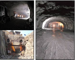
- Package-I consisted of construction of Two Tunnels (Two Tubes of 4 lanes each) of length 1.75 km and 8.92 km respectively.
- Package-II consisted of eight lane two viaducts of length 790 m. and 650 m. respectively with Capacity Augmentation (6 lane to 8 lane) of existing expressway.
MSRDC relied upon Ceinsys to use Geographic Information System (GIS) with Information Technology (IT) as one of the key enablers for executing and monitoring the project. GIS based Progress Monitoring System development is the crux of the project through which users can view the status of the project, run queries on the extensive spatial database developed by acquiring HD drone images and have all the data in the dynamic reports format thus generated.
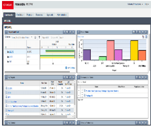
Engaging an OEM based 3D modelling and extended to time scheduling for 4D realization and cost monitoring for 5D realization, the project delivered a state-of-the-art integrated ‘Digital Project Management Platform’ (DPMP), consisting of a 5D Building Information Modelling (BIM) using BIM enabled Common Data Environment (CDE), Enterprise Resource Planning (ERP) System, Business Analytics System (BAS), Geographic Information System (GIS) and Facility Management Services (FMS). This digital platform is made accessible to all the project stakeholders by setting up Owner Support Office (OSO) & the state-of-the-art Command Centre and facility management.
The DPMP is an integrated platform, which collaborates SAP ERP, Bentley Synchro, Bentley Common Data Environment (CDE) along with Business Analytics System (BAS) to perform various independent business functions in close coordination. Providing a walkthrough of the various applications involved for MSRDC DPMP to monitor the project progress across the two Contract Packages for MPEW project.
Implementation of Digital Project Management system using GIS web-based application ensured:
- 3D realization & visualization of 17 Km of road alignment and infrastructure assets.
- Digital realization of tunnels and viaduct.
- Engaging 4D & 5D for real time monitoring resulting in 20% saving in time and cost over-run.
- Single source of truth to avoid duplications optimizing operational efficiencies.
- Integrated Project Land Acquisition Status with actual view of Land parcel.
Integrated dashboard system to visualize high level project health.