


 Tech Play
Design Solution For GIS Enabled Property & Tax Information System
Indore is city in the heart of the third largest state of India, Madhya Pradesh. Being the IT Capital of the state, the city accommodates more than 10 million of the population. With the rapid advancements in the city’s growth and development, the economy of the state is undergoing phenomenal changes. To keep up with the times, it is important to validate, improve, and reengineer business processes. The Municipal Corporation of Indore (IMC) realized the need to update and revitalize its property tax collection system in order to increase revenue. With a projected YoY growth of 11% in the population of the city, the IMC planned to undertake multi-dimensional efforts, including consolidating and reclassifying the existing property database on a user-friendly and robust computerized solution platform. The existing tax-payers data collection was a huge and challenging job. The revenue department was facing a great amount of loss because of the lack of count of unassessed properties under its jurisdiction, manual efforts being done to capture the data leading to data redundancy and hence tax system failure.
To eradicate this problem statement, Ceinsys Tech Ltd, introduced GIS as the task bearer and devised an enterprise solution which empowered decision-makers to make informed decisions about taxation, efficiently collect taxes, and maximize the utilization of manpower resources for revenue collection.
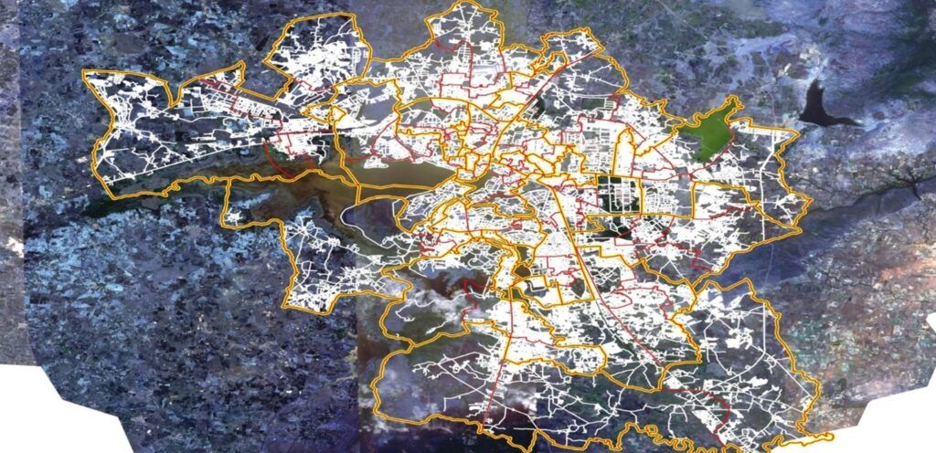
Ceinsys addressed the challenge and solutionized the problem statement using the concept of GIS and Remote Sensing engaging the thorough deployment of Very High-Resolution Satellite Imagery and generation of detailed base maps on a scale of 1:1K. The existing ancillary data was collected from the revenue department and based on the survey conducted to acquire the latest data was updated on the satellite imagery.
The Base Map thus generated, consisted of features like facility layer for urban and rural areas, building foot prints, transportation layers, water bodies. utilities, etc…
Along with this, a dedicated team of experts was commissioned to provide end to end development of the solution which included property survey, data collation, data rationalization, conceptualization, development of the web and mobile application, hosting services, remote web site management and application maintenance. A unique ID was developed for each and every property under the IMC jurisdiction which was geo-tagged for the creation of a consolidated Geodatabase. The assessed properties were broadly divided in to three categories:
- Residential
- Non-residential
- Open Plots
To calculate the value of any property, an “Annual Letting Value of the Land” formula was generated based on Location of property, Nature of construction, Level of services, Age and present condition of building, location advantage of property, Prevailing rents for similar buildings, The rent fixed either by contract or law. The overall system is developed using ESRI ArcGIS server technology and a centralized RDBMS database to store land information. The ESRI’s commercial off-the-shelf (COTS) ArcGIS, Web Mapping Services were used to publish the data on the portal developed specifically to address the needs of the user.
Key project activities:
- Engaging Very High-Resolution Satellite Imagery with 0.3 m of spatial resolution.
- Property surveys, mapping and High-Resolution GIS base map preparation on a scale of 1:1K.
- Utility layer covering major layers of Main roads & other important roads, railways, airport, cantonment areas & important landmarks, colony names, Drains, canals, rivers and other water bodies.
- Property layer covering Plot and Building footprint with unique IDs., Vacant lands Municipal area boundary, zone, ward boundaries and tax zones.
- Customized web-based GIS solution for the property tax improvement.
- Enterprise GIS Portal development for internal & external users.
- Decision Support System being updated with real time information
- Review and Reassessment of present Revenue Collection
- Mobile application development for field personals
- Executive Dashboard for key official & Decision makers
- Transparency in Location-based Data offers Citizens’ Satisfaction.
The project provided with 27 data layer digitization with more than 6 million properties mapped and ensured a 10% increase in the built-up area when compared with the recorded area. This benefitted the Municipal corporation with 40% revenue enhancement.