


 Tech Play
Subsidized by World Bank, Karnataka Watershed Development Project – II (Sujala-III) is being actualized by Watershed Development Department (WDD) of Government of Karnataka. The
venture is gone for fortifying the science-based watershed administration including arrangement of new instruments and procedures for science-based arranging in Integrated Watershed Management Program (IWMP). Land data being basic for above, it is proposed to build up a dynamic condition of-craftsmanship GIS based Land Resource Inventory (LRI) Geoportal which can ingest, compose, oversee and spread information from different sources (spatial and non-spatial) for improving choice help to the partners including arranging and economic advancement of land assets for different applications. The proposed framework should fill in as a typical operational stage giving noteworthy insight and situational attention to every one of its partners. The proposed framework is likewise anticipated that would meet the national/state level targets with respect to manageable improvement of farming, calamity arranging and recuperation, foundation arranging and regular assets appraisal and assignment, rustic advancement, instruction, and so forth.
The purpose of the project was to develop and deploy state-of-the-art centralized ICT platform for the state of Karnataka which could integrate data from multiple sources and provide seamless access of information over user friendly platforms including Web and mobile platforms. This was expected to facilitate effective usage of the data by farming, scientific community and policy makers for efficient and improved decision making. The project targeted establishing a state-of-the-art Digital Library (DL), Watershed Management Portal for robust and dynamic Decision Support System (DSS). This was based upon Dynamic state-of-art GIS based Land Resource Inventory Portal with LRI DSS, ICT tools, network & environmental controls to collect & integrate Data from Multiple Sources to enable sustainable development of natural resources
Ceinsys Tech Ltd., proposed an end-to-end solution which aimed at design, development and deployment of a Land Resource Inventory (LRI) & a Geodata clearinghouse comprising of LRI Data centre, LRI Geo Portal and LRI Decision Support System (DSS) accessible over World Wide Web / distributed networks / mobile apps.
The proposed solution consisted of design & development of:
- Land Resource Inventory (LRI)
- Geodata clearinghouse comprising of LRI Data centre
- LRI Enterprise Geo Portal
- LRI decision support system (DSS) accessible over World Wide Web / distributed networks / mobile apps.
- Decision support systems: 9 modules
- Crop Selection
- Nutrient Management & Soil health
- Crop Water Requirement
- Soil Conservation structures
- Water balance estimation
- Water budgeting calculation
- Land capability classification
- Surface run-off calculation
- Farm pond location, sizing & designing
- Mobile application
- Farmer Advisory services
One of the challenges faced in the project was the assimilation of enormous data (spatial & non-spatial) at a single location. This was resolved with the help of LRI data generating partners. To store the data at a centralized location, a Data Centre was established and is located at State Data Center at Bengaluru, Government of Karnataka whereas the Disaster Recovery Centre is located at University of Agricultural Sciences, Dharwad.
The overall solution was developed using COTs:
- ERDAS Imagine
- Apollo Server
- Geo-Portal
- Geomedia WebMap
- Geomedia Professional
CMS: Orchard
Mobile Application: Android & iOS
The platform enabled farmers and the scientific community to manage fertilizer utilization for any crop at any stage, under any condition and growing method, taking into account the multiple dynamic factors required for optimizing crop growth. Benefits of decision support systems include for Famers & Watershed Development Department more informed decision-making, timely problem solving and improved efficiency for dealing with problems with rapidly changing variables. Common operational platform providing actionable intelligence and situational awareness to all its stakeholders like Farmers, Departments, Hydrologists. Due to the availability of site-specific LRI database on real time basis through the Portal, the interventions have become more focused and farmer and youth oriented rather than remaining as a blanket or general type as was the case in earlier programs, The watershed cycle is reduced to 3 to 4 years which used to take about 6 to 7 years earlier. Real time convergence of various programs and budgetary allocations to line departments as per the requirement have become more realistic. More than anything, the time, capital and manpower use efficiency has increased significantly due to the application of this approach.
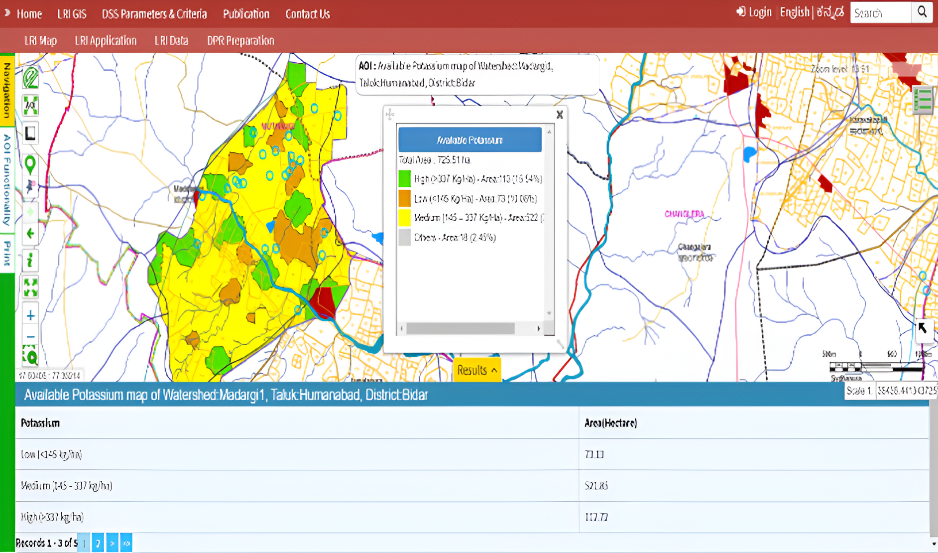
Dashboard:

Decision Support System Modules:
