


 Tech Play
GIS-Asset mapping of Optical Fibre Cable laying route Using GIS for FTTH services
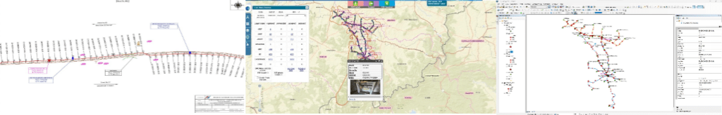
Bharat Sanchar Nigam Limited (BSNL), is the largest Indian state-owned telecommunications company. The company is pioneer in Indian telecom industry and operating through more than 30 circles / regions. BSNL planned to digitally map its route for creation of the As-Built drawings of the existing and future network assets in order to generate a centralized GIS based Optical Fibre Cable (OFC) Network Management system. Ceinsys having more than 25+ years of experience in the GIS domain performed the task of GIS mapping of existing & future OFC Routes using state-of-the-art LiDAR technology having mobile mapping system embedded with 360° panoramic imagery camera. The project is meant to identify the future prospects of growth in urban as well as sub-urban areas through National Long Distance and Intra-city route survey. Overall centralized GIS based (OFC) Network Management system was implemented for BSNL network.
The broad scope of work involved National Long Distance and Intra-city route survey and preparation of geo-referenced As-Built Map using state of the art technology i.e. Mobile Mapping System integrated with Mobile LiDAR System (MLS), Mobile 3600 Panoramic Imaging System (PIS), IMU and GPS for Intra-City and National Long Distance routes. As built maps were prepared using supporting documents like Single Line Diagram, Measurement Book, HDD Graph etc wherever available along with physical survey.
The major components of the Scope of Work involved GIS Platform development for the complete network being
surveyed followed by the data conversion of existing As-Built Drawings in various formats with Geo-reference details, As-Built Map. Preparation (OSP & ISP) & Validation. The overall geodatabase was then integrated with other existing subsystems.
Key project activities:
• Field Survey for GIS mapping of existing & future OFC Routes using LiDAR Technology having mobile mapping system integrated with DGPS devices and preparation of GIS mapped As Built Diagrams.
• Conversion of existing As-Built Diagrams of the designated OFC routes into GIS maps without field survey.