


 Tech Play
GIS-powered Asset Management & Land Administration System
Maharashtra Industrial Development Corporation (MIDC) is the premier industrial infrastructure development agency for the state of Maharashtra. MIDC is at the forefront in driving e -governance and digital initiatives for ease of doing business, having single window clearance system, online approach for tendering and land base planning & allotment and industrial areas structuring. However, the planning in industrial areas has always been a challenging and tedious task for the authorities. The socio-economic development of the state, the development of specialized parks/industrial clusters with specialized infrastructure facilities generates multiple revenue streams for the state’s development. When it comes to state-level, there are multiple districts with huge industrial area lands. These lands, due to their size and complex structure are not easy to manage since they rely on decades old technology of paper-based record keeping. The ownership of these lands is also ambiguous since for a single piece of land there are n nos. of land owners. This results in duplicity of the records and hence the revenue losses.
This problem statement was presented in front of Ceinsys Tech Ltd. In order to get a simplified solution. To overcome the complex process of land management, Ceinsys has designed and developed a web-based land management enterprise solution for the industrial areas which has proved as boon for the industrial area development and curbed down the revenue losses. Ceinsys in consultation with the Industrial Authorities undertook a detailed User Needs Assessment to better understand the requirements and come up with the best suitable solution. We devised a solution which was based on drone survey analytics and commissioned a dedicated team that comprised of Survey experts, GIS/Remote sensing experts and software experts to provide end to end development of the solution included drone survey, data collation, data rationalization, conceptualization, development of the portal, mobile application, hosting services, remote web site management and application maintenance.
The majority of the data was collected from Architecture & Town Planning Department which comprised of CAD files for:
- Industrial Area Boundary
- Area Statement
- Plot No. & Plot Area
- Land Use Index
- Open Space
- Amenities details
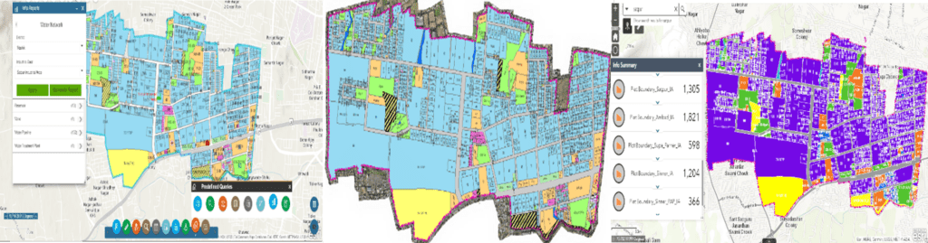
Post scrutinizing the data, a thorough high-end drone survey was conducted around the buffer boundary to capture the entire area with an accuracy of 3-5 cms. The building footprints were digitized in order to generate a detailed base map. The database thus generated consisted of industrial area layers, water boundaries, admin boundaries, transportation, residential etc. This geodatabase was migrated and integrated with the existing infrastructure. Simultaneously, a change detection operation was performed with the data freshly generated and compared with the existing data. The integrated map-view showed a tremendous growth in the areas/boundaries and hence a shift in the existing database of the corporation.
The overall system is developed using ESRI ArcGIS server technology and a centralized RDBMS database to store land information. This solution has paved way to detect the encroached lands and provide a mechanism for urban/rural land change detection & its monitoring.
Key project activities included:
- Drone survey for the Image data acquisition of industrial area.
- Geodatabase creation and High-Resolution GIS map creation.
- Industrial area utility data creation.
- Existing data sanitization and migration.
- Enterprise GIS Portal development for internal & external users.
- Process atomization for new industrial area plan development and approval and changes in existing industrial area plan.
- Mobile application development for field personals.
- Integration of existing enterprise systems – ERP, LAS, LMS, BPAMS, SWC, WMS.
- Establishment of GIS Cell for day-to-day Operation and Maintenance.
- Executive Dashboard for key official & Decision makers.
The Enterprise Geospatial Solution for the Land Management System developed is the first of its kind state of the art solution in the country ensured the State-wide Implementation of Web GIS-based tracking of land information covering 66,000 Ha of area. The solution was implemented for 284 Industrial Areas. This resulted in identification and quantification of land encroachment. The integration with the existing application for identification of revenue loss loop hole provided a single window interface for managing and tracking land management activities. A robust mobile application along with a web- based application was developed for real time on ground land and facility status tracking and provided with better operational efficiency and decision making by Executive Dashboard.
The project also promoted a paperless environment and effective monitoring mechanism, thereby reducing the time and cost in the land management process